Key takeaways
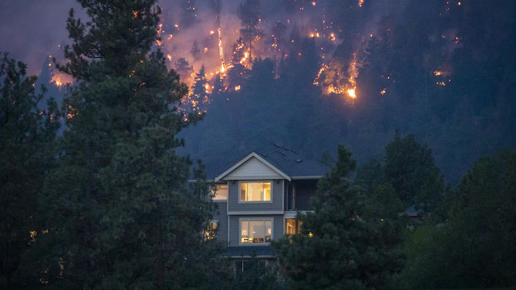
- BC's 2026 wildfire season has started early. As of April 28, 22 active fires were burning across the province; drought and El Niño conditions are elevating risk for the months ahead.
- The same week, Public Safety Canada announced the technical completion of Canada's Flood Risk Finder — a national address-level flood risk portal. There's no equivalent for wildfire.
- Federal wildfire data (NRCan, the Canadian Wildland Fire Information System) is excellent for operational intelligence — fire weather, active fires, fire behaviour — but doesn't yet provide address-level risk mapping comparable to the flood tool.
- Wildfire has produced some of Canada's largest insured natural disasters in the past decade. The data infrastructure to support property-level decisions hasn't kept up.
- What to do in the meantime: pair federal operational data with private property-level risk tools.
Two announcements, one week apart
On April 27, Public Safety Canada announced that Canada's Flood Risk Finder had completed technical development. Once provinces opt in, any Canadian will be able to enter an address into a federal portal and see a four-point flood risk rating, alongside the type of flooding expected. We wrote about it last week.
On April 28, CBC reported that BC already has 22 active wildfires burning. Officials are emphasizing the importance of communication as a difficult season takes shape, with drought and El Niño conditions setting up dry fuel across the province.
The contrast is hard to miss. For flood, Canada is moving toward a single national, address-level risk portal. For wildfire — historically the most expensive natural-disaster category in the country — the federal data infrastructure looks fundamentally different.
What Canada has for wildfire data
The federal wildfire data ecosystem is real, and it's good. It just answers a different question.
- The Canadian Wildland Fire Information System (CWFIS), operated by Natural Resources Canada's Canadian Forest Service, publishes near-real-time fire weather indices, fire behaviour predictions, and active fire detections sourced from satellite. It's the operational backbone of fire management across Canada.
- The Canadian Forest Service publishes the National Burn Severity dataset — historical burned areas mapped from satellite — plus the fire behaviour and danger rating models used by every provincial wildfire agency.
- Provincial agencies — the BC Wildfire Service, Alberta Wildfire, the Ontario Ministry of Natural Resources and Forestry, and others — operate the on-the-ground response, manage prescribed burns, and publish active-fire dashboards specific to their jurisdictions.
- NRCan also produces national-scale wildland fire risk assessments and contributes to the National Risk Profile, a strategic-level document on disaster risks across Canada.
This system answers: Is there a fire near here right now? How dangerous are the conditions today? Where have fires burned in the past?
It doesn't directly answer: Is my address in a wildfire-prone area, on the same scale and methodology, regardless of which province the address sits in?
What it doesn't have
There is no Canadian federal portal where a homeowner, lender, or broker can:
- Enter a Canadian address
- Receive a consistent property-level wildfire risk rating, comparable across provinces
- Use that rating in mortgage diligence, insurance underwriting, or portfolio analysis
The Flood Risk Finder, when fully rolled out, will provide this for flood. The wildfire equivalent doesn't exist.
That gap matters.
Why the asymmetry exists
Three reasons, briefly.
1. Jurisdictional history. Flood has long been treated as a national-coordination problem — the federal Flood Hazard Identification and Mapping program, the Federally Identified Flood Risk Areas dataset, a clear shared-responsibility model with provinces and territories. Wildfire is more deeply provincial: each province has its own wildfire agency, its own fuel and weather profile, its own response model.
2. The data is harder to harmonize. Flood risk at a property is largely a function of geography that doesn't change quickly — proximity to water, elevation, soil saturation. Wildfire risk depends on fuel type, vegetation density, weather, fire history, and human factors (ignition probability, defensible space, building materials), and much of that information lives at the provincial or municipal level — or inside proprietary insurer datasets.
3. Different policy attention. Flood mapping has been a federal priority for over a decade, partly because flood was uninsurable in much of Canada until 2016 and remains the largest source of disaster assistance payments. Wildfire's status as a federal-attention issue is more recent — really since Fort McMurray in 2016 — and the policy infrastructure around it is still catching up.
None of this is a critique of NRCan or the wildfire community. It's an observation that the data infrastructure for two of Canada's most important physical climate hazards is on different trajectories.
Why this matters for property owners, lenders, and insurers
Wildfire is where the money is.
- Fort McMurray (2016) alone produced an estimated $3.7 billion in insured losses — the largest insurance event in Canadian history at the time.
- 2023 was Canada's most destructive wildfire season on record by area burned.
- The Insurance Bureau of Canada has repeatedly flagged wildfire as one of the fastest-growing categories of insured loss.
For a Canadian property owner, lender, or insurer, the cost of a single severe wildfire event near a property can dwarf the cost of a comparable flood. And yet, the publicly available federal data tools answer "where's the fire today?" far better than they answer "how exposed is this address structurally?"
That gap doesn't get closed by federal awareness tools alone. It gets filled by a combination of:
- Federal operational intelligence (CWFIS, fire danger ratings)
- Provincial wildfire mapping where it exists
- Private climate analytics platforms that integrate national fuel maps, fire history, weather, and structural exposure
- Insurer-side proprietary models
For professional users, the workflow is a stack, not a single tool. That's likely true for the foreseeable future — even if a national wildfire risk portal eventually emerges, it'll be a baseline, not the whole answer.
What to do this season
Practical implications, by audience.
Homeowners and renters in BC, AB, ON, and QC
- Track CWFIS daily during fire season for active fires and fire-weather conditions in your area.
- Use FireSmart guidance for defensible space and home hardening — these have larger marginal impact than any data tool.
- For property-level risk awareness before the season ramps up, postal-code-level tools — including ClimaInsight's free screening — can give you a directional read using the national Wildland Fire Risk Index.
Insurance and mortgage brokers
- Don't assume "no active fire today" means "low risk." Property-level wildfire risk is a structural condition, not a current event.
- For BC and AB clients, expect more frequent climate-risk questions than for clients elsewhere.
- A federal wildfire portal isn't coming this summer. Pair public data (CWFIS, NRCan) with a property-level screening tool for client conversations.
Commercial real estate and lenders
- Asset-level wildfire screening should already be part of new acquisition and renewal underwriting in BC, AB, and northern ON. If it isn't, this season is a good time to build it in.
- Federal data alone won't satisfy OSFI B-15 documentation expectations. The "show your work" requirement applies to wildfire as much as flood.
- Portfolio-level views — what share of properties sit in moderate / high / extreme wildfire risk areas — are far more useful than single-property snapshots for capital and concentration decisions.
OSFI-regulated entities
- The same B-15 framework applies. Wildfire risk should be quantified, methodologically defensible, and integrated with portfolio data — not treated as a future federal-tool problem.
- IFRS S2 disclosures will increasingly expect entity-level wildfire exposure metrics, particularly for insurers and mortgage lenders with western Canadian portfolios.
The bigger picture
Last week's Flood Risk Finder announcement was, among other things, a signal that Canada is moving toward consolidated federal climate-hazard infrastructure for at least one major hazard category. Wildfire isn't there yet — and may not be on the same timeline, given the structural reasons above.
In the meantime, the gap will be filled the way data gaps usually are: a layered stack of public, provincial, and private tools, used together.
For BC professionals heading into the 2026 season, the practical implication is straightforward: don't wait for a national wildfire risk portal that may not come for years. The data to make better decisions is already there — it's just spread across more places than the flood equivalent will be.
Sources: CBC News, "B.C. communities say communication is key as wildfire season begins", April 28, 2026; Public Safety Canada news release on Canada's Flood Risk Finder, April 27, 2026; Natural Resources Canada — Canadian Wildland Fire Information System.